Weather Alerts for New Mexico
1. Fire Weather Watch for: Northeast Plains; Sangre de Cristo Mountains; Northeast Highlands; Sandia and Manzano Mountains; Central Highlands; East Central Plains
2. Fire Weather Watch for: Sacramento Foothills and Guadalupe Mountains; Chaves County Plains; Eddy Plains; Lea; Loving; Guadalupe Mountains Above 7000 Feet; Guadalupe and Delaware Mountains; Van Horn and Highway 54 Corridor; Eastern Culberson County; Reeves County Plains; Davis Mountains; Davis Mountains Foothills
3. Fire Weather Watch for: Southwest Mountains; Southwest Deserts and Lowlands; South Central Lowlands And Southern Rio Grande Valley; Capitan And Sacramento Mountains; El Paso; Hudspeth
4. Flood Advisory for: Rio Arriba, NM
5. Flood Advisory for: Rio Arriba, NM
6. High Wind Warning for: Guadalupe Mountains of Eddy County; Guadalupe Mountains Above 7000 Feet; Guadalupe and Delaware Mountains
7. High Wind Warning for: Northern Sangre de Cristo Mountains; Southern Sangre de Cristo Mountains; East Slopes Sangre de Cristo Mountains; Central Highlands; Johnson and Bartlett Mesas Including Raton Pass
8. Red Flag Warning for: Northeast Plains; Sangre de Cristo Mountains; Northeast Highlands; Sandia and Manzano Mountains; Central Highlands; East Central Plains
9. Red Flag Warning for: Northeast Plains; Sangre de Cristo Mountains; Northeast Highlands; Sandia and Manzano Mountains; Central Highlands; East Central Plains
10. Red Flag Warning for: Northwest Plateau; West Central Mountains; Middle Rio Grande Valley; West Central Basin and Range; North Central Mountains; Upper Rio Grande Valley and Lower Chama River Valley
11. Red Flag Warning for: Northwest Plateau; West Central Mountains; Middle Rio Grande Valley; West Central Basin and Range; North Central Mountains; Upper Rio Grande Valley and Lower Chama River Valley
12. Red Flag Warning for: Sacramento Foothills and Guadalupe Mountains; Chaves County Plains; Eddy Plains; Lea; Loving; Guadalupe Mountains Above 7000 Feet; Guadalupe and Delaware Mountains; Van Horn and Highway 54 Corridor; Eastern Culberson County; Reeves County Plains; Davis Mountains; Davis Mountains Foothills
13. Red Flag Warning for: Southwest Mountains; Southwest Deserts and Lowlands; South Central Lowlands And Southern Rio Grande Valley; Capitan And Sacramento Mountains; El Paso; Hudspeth
14. Red Flag Warning for: Southwest Mountains; Southwest Deserts and Lowlands; South Central Lowlands And Southern Rio Grande Valley; Capitan And Sacramento Mountains; El Paso; Hudspeth
15. Wind Advisory for: Glorieta Mesa Including Glorieta Pass; Upper Rio Grande Valley; Sandia/Manzano Mountains Including Edgewood; Estancia Valley; Far Northeast Highlands; Northeast Highlands; Harding County; Eastern San Miguel County; Guadalupe County; Quay County; Curry County; Roosevelt County; De Baca County
16. Wind Advisory for: Northern Sangre de Cristo Mountains; Southern Sangre de Cristo Mountains; East Slopes Sangre de Cristo Mountains; Central Highlands; Johnson and Bartlett Mesas Including Raton Pass
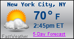
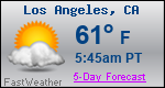
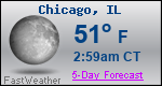
Want more detail? Get the Complete 7 Day and Night Detailed Forecast!
Current U.S. National Radar--Current
The Current National Weather Radar is shown below with a UTC Time (subtract 5 hours from UTC to get Eastern Time).

National Weather Forecast--Current
The Current National Weather Forecast and National Weather Map are shown below.

National Weather Forecast for Tomorrow
Tomorrow National Weather Forecast and Tomorrow National Weather Map are show below.

North America Water Vapor (Moisture)
This map shows recent moisture content over North America. Bright and colored areas show high moisture (ie, clouds); brown indicates very little moisture present; black indicates no moisture.

Weather Topic: What is Evaporation?
Home - Education - Precipitation - Evaporation
 Next Topic: Fog
Evaporation is the process which returns water from the earth
back to the atmosphere, and is another crucial process in the water cycle.
Evaporation is the transformation of liquid into gas, and it happens because
molecules are excited by the application of energy and turn into vapor.
In order for water to evaporate it has to be on the surface of a body of water.
Next Topic: Fog
Weather Topic: What are Fractus Clouds?
Home - Education - Cloud Types - Fractus Clouds
 Next Topic: Freezing Rain
A fractus cloud (scud) is a fragmented, tattered cloud which has
likely been sheared off of another cloud. They are accessory clouds, meaning they
develop from parent clouds, and are named in a way which describes the original
cloud which contained them.
Fractus clouds which have originated from cumulus clouds are referred to as
cumulus fractus, while fractus clouds which have originated from stratus clouds
are referred to as stratus fractus. Under certain conditions a fractus cloud might
merge with another cloud, or develop into a cumulus cloud, but usually a
fractus cloud seen by itself will dissipate rapidly.
They are often observed on the leading and trailing edges of storm clouds,
and are a display of wind activity.
Next Topic: Freezing Rain