Weather Alert in Wisconsin
Red Flag Warning issued May 12 at 12:14PM CDT until May 12 at 9:00PM CDT by NWS Green Bay WI
AREAS AFFECTED: Vilas; Oneida; Forest; Florence; Northern Marinette County; Lincoln; Langlade
DESCRIPTION: ...CRITICAL FIRE WEATHER CONDITIONS EXPECTED THIS AFTERNOON AND THIS EVENING... .Southerly winds gusting 15 to 20 mph, low relative humidity, and above normal temperatures will lead to critical fire weather conditions on Monday. * AFFECTED AREA...Vilas, Oneida, Forest, Florence, Northern Marinette County, Lincoln and Langlade. * TIMING...Until 9 PM CDT this evening. * WINDS...South 10 to 15 mph with gusts up to 20 mph. * RELATIVE HUMIDITY...15 to 25 percent. * TEMPERATURES...In the mid 80s. * IMPACTS...Fires will start easily and spread quickly in these conditions. So outdoor burning should not be attempted. Visit the Wisconsin DNR website at apps.dnr.wi.gov/wisburn/#/BurnRestrictions and click on the appropriate county to view current burning restrictions.
INSTRUCTION: A Red Flag Warning is issued when critical fire weather conditions are either occurring now, or are imminent. A combination of strong winds, very low relative humidity, warm temperatures and exceptionally dry fuels will create dangerous wildland fire conditions. Persons are urged to be careful with any activities that could potentially lead to a wildland fire. Campfires, outdoor grills, smoking materials, chain saws, and all- terrain vehicles all have the potential to throw a spark and ignite a dangerous and destructive fire. Please advise the appropriate officials or fire crews in the field of this red flag warning.
Want more detail? Get the Complete 7 Day and Night Detailed Forecast!
Current U.S. National Radar--Current
The Current National Weather Radar is shown below with a UTC Time (subtract 5 hours from UTC to get Eastern Time).

National Weather Forecast--Current
The Current National Weather Forecast and National Weather Map are shown below.

National Weather Forecast for Tomorrow
Tomorrow National Weather Forecast and Tomorrow National Weather Map are show below.

North America Water Vapor (Moisture)
This map shows recent moisture content over North America. Bright and colored areas show high moisture (ie, clouds); brown indicates very little moisture present; black indicates no moisture.

Weather Topic: What are Altocumulus Clouds?
Home - Education - Cloud Types - Altocumulus Clouds
 Next Topic: Altostratus Clouds
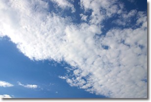
Similar to cirrocumulus clouds, altocumulus clouds are
characterized by cloud patches. They are distinguished by larger cloudlets
than cirrocumulus clouds but are still smaller than stratocumulus clouds.
Altocumulus clouds most commonly form in middle altitudes (between 2 and 5 km)
and may resemble, at times, the shape of a flying saucer.
These uncommon formations, called altocumulus lenticularis, are created by uplift
in the atmosphere and are most often seen in close proximity to mountains.
Next Topic: Altostratus Clouds
Weather Topic: What are Cirrocumulus Clouds?
Home - Education - Cloud Types - Cirrocumulus Clouds
 Next Topic: Cirrostratus Clouds
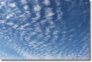
Cirrocumulus clouds form at high altitudes (usually around 5 km)
and have distinguishing characteristics displayed in a fine layer of
small cloud patches. These small cloud patches are sometimes referred to as
"cloudlets" in relation to the whole cloud formation.
Cirrocumulus clouds are formed from ice crystals and water droplets. Often, the
water droplets in the cloud freeze into ice crystals and the cloud becomes a
cirrostratus cloud. Because of this common occurrence, cirrocumulus cloud
formations generally pass rapidly.
Next Topic: Cirrostratus Clouds
Current conditions powered by WeatherAPI.com


