Weather Alert in Kansas
Flash Flood Warning issued June 3 at 4:47PM CDT until June 3 at 8:45PM CDT by NWS Wichita KS
AREAS AFFECTED: Greenwood, KS; Woodson, KS
DESCRIPTION: FFWICT The National Weather Service in Wichita has issued a * Flash Flood Warning for... Southern Greenwood County in southeastern Kansas... Woodson County in southeastern Kansas... * Until 845 PM CDT. * At 447 PM CDT, Doppler radar indicated thunderstorms producing heavy rain across the warned area. Flash flooding is ongoing or expected to begin shortly. HAZARD...Life threatening flash flooding. Thunderstorms producing flash flooding. SOURCE...Radar estimated 2 to 5 inches of rainfall over the past 3 hours. An additional 2 to 4 inches are possible through 6 PM. IMPACT...Life threatening flash flooding of creeks and streams, urban areas, highways, streets and underpasses. * Some locations that will experience flash flooding include... Eureka, Yates Center, Toronto, Severy, Fall River, Neosho Falls, Climax, Virgil, Toronto Lake, Cross Timbers State Park, Batesville, Fall River State Park, Fall River Lake, Rose, Piqua and Piedmont. This includes the following streams and drainages... Chelsea Township, Plum Creek, Walnut Creek, Bachelor Creek, Miller Creek, Pawpaw Creek, Sandy Creek, Indian Creek, Homer Creek, Kitty Creek, Watson Branch, Tadpole Creek, Elk River, Brazil Creek, Shawnee Creek, Slate Creek, Otter Creek, West Buffalo Creek, West Creek, Badger Creek, South Branch Otter Creek, Owl Creek, Cedar Creek, Rowe Branch Elk River, Bloody Run, Rock Creek, North Branch Otter Creek, Buffalo Creek, Onion Creek, Ross Branch, Scatter Creek, Dry Creek, Durham Creek, Meadow Creek, Crain Creek, North Owl Creek, Village Creek, Greenhall Creek, Little Salt Creek, Snake Creek, Turkey Creek, Carlisle Branch, Swing Creek, Cherry Creek, Honey Creek, Fall River, North Branch Hickory Creek, South Owl Creek, Little Sandy Creek, Salt Creek, Spring Creek, Tar Creek, Neosho River, Duck Creek and Verdigris River.
INSTRUCTION: Do not drive into flooded areas or go around barricades. Nearly two feet of water will carry most vehicles away. Turn around, don't drown.
Want more detail? Get the Complete 7 Day and Night Detailed Forecast!
Current U.S. National Radar--Current
The Current National Weather Radar is shown below with a UTC Time (subtract 5 hours from UTC to get Eastern Time).

National Weather Forecast--Current
The Current National Weather Forecast and National Weather Map are shown below.

National Weather Forecast for Tomorrow
Tomorrow National Weather Forecast and Tomorrow National Weather Map are show below.

North America Water Vapor (Moisture)
This map shows recent moisture content over North America. Bright and colored areas show high moisture (ie, clouds); brown indicates very little moisture present; black indicates no moisture.

Weather Topic: What are Cirrocumulus Clouds?
Home - Education - Cloud Types - Cirrocumulus Clouds
 Next Topic: Cirrostratus Clouds
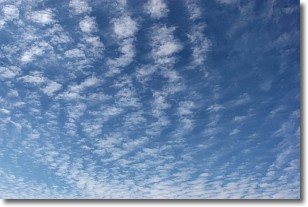
Cirrocumulus clouds form at high altitudes (usually around 5 km)
and have distinguishing characteristics displayed in a fine layer of
small cloud patches. These small cloud patches are sometimes referred to as
"cloudlets" in relation to the whole cloud formation.
Cirrocumulus clouds are formed from ice crystals and water droplets. Often, the
water droplets in the cloud freeze into ice crystals and the cloud becomes a
cirrostratus cloud. Because of this common occurrence, cirrocumulus cloud
formations generally pass rapidly.
Next Topic: Cirrostratus Clouds
Weather Topic: What are Cirrus Clouds?
Home - Education - Cloud Types - Cirrus Clouds
 Next Topic: Condensation
Cirrus clouds are high-level clouds that occur above 20,000 feet
and are composed mainly of ice crystals.
They are thin and wispy in appearance.
What do they indicate?
They are often the first sign of an approaching storm.
Next Topic: Condensation
Current conditions powered by WeatherAPI.com


