Weather Alert in Alaska
Flood Warning issued August 13 at 8:16AM AKDT until August 14 at 8:00AM AKDT by NWS Juneau AK
AREAS AFFECTED: City and Borough of Juneau
DESCRIPTION: Mendenhall River crested at 715 am at 16.65 feet and is currently 16.45 feet at 745 am. River levels will continue to fall at the lake and will crest in downriver areas in the next 15 minutes to an hour. Please heed any road closures and local Emergency Management guidance. * WHAT...Flooding caused by a glacier-dammed lake outburst continues. * WHERE...The Mendenhall Lake and River near areas around the glacier visitor center, the Mendenhall campground, Skaters Cabin Road, View Drive and possibly below Back Loop bridge. * WHEN...Until 800 AM AKDT Thursday. * IMPACTS...Flooding near Mendenhall Lake and River locations is occurring. * ADDITIONAL DETAILS... - At 800 AM AKDT, Mendenhall River crested at 715 am at 16.65 feet and is currently 16.45 feet at 745 am. River levels will continue to fall at the lake and will crest in downriver areas in the next 15 minutes to an hour. Please heed any road closures and local Emergency Management guidance. - The outburst flood forecast is based on an estimated volume of water in the glacier dammed lake and an estimated release rate based on previous events. The extent of water drainage within the basin (partial or full) can vary widely between outburst flood events and is a major source of uncertainty in the forecast, particularly with regard to the peak flood stage. - For Mendenhall Lake: As of 8am, the lake levels are expected to continue to fall. For areas downstream of Backloop Bridge: Water levels are expected to crest over the next 15 miniutes to an hour. Impacts: At 11.0 feet: Some homes along View Dr will have up to 1.5 feet of water in yards. Locations below back loop bridge will see bank erosion along unreinforced river banks along with hazardous navigation from debris in the river. Homes along the river on Meander Way will begin to see flooding of some backyards on the outside of the HESCO levee. Portions of the Dredge Lake Trail System will be impassable. Flood waters start to reach Dredge Lake. At 11.5 feet: The low section of road past 9374 View Dr will begin to flood along with water approaching some homes towards the end of road. At 12.0 feet: Significant bank erosion along unreinforced river banks. The low section of road past 9374 View Dr will be flooded with up to 0.5 feet of water. Some houses on the south side and the east end of View Dr will start to flood. Water begins to flood some backyards of homes on the northside of View Dr as well as other low lying areas. Back Loop Rd Bridge will be closed during outburst events. At 12.5 feet: 2 to 4 feet of water in some backyards along Meander Way on the the river side of the HESCO levee. At 13.0 feet: The low section of road past 9374 View Dr will be flooded with 2 ft of water. Water begins to flow through some backyards of homes on the northside of View Dr and flood low lying areas. A few locations on View Dr will see depths of 1 to 2 feet of water in homes. At 13.5 feet: Water starts to back up behind homes between Riverside Dr at Tournure St and Mendenhall River School. Locations on River Rd with low river banks will begin to see water inundate yards. Severe bank erosion along unreinforced river banks. At 14.0 feet: The low section of road past 9374 View Dr will be significantly flooded and impassable. Water will begin to flow over the road from water flowing behind homes on the north side of View Dr. More homes along View Dr will begin to see moderate to major flooding. Locations on River Rd with low river banks will begin to see water approach driveways. At 15.0 feet: Major flooding of multiple homes along View Dr. Water will begin to approach a few homes along River Rd with low river banks with possible flooding of driveways and 1 to 2 feet of water in backyards. Up to 1 foot of water covering Riverside Dr at Tournure St and Mendenhall River School. At 16.0 feet: Water starts to overtop the bank and flood low lying areas near Wildmeadow Ln. Up to 0.5 feet of water will be in the intersection of Skaters Cabin Rd and Arctic Cir. Some backyards of homes between Tamarack Ct and Whitewater Ct will start to see flood waters along with water approaching River Rd near homes with low river banks and possibly flooding those homes. Water will start to flood backyards of homes on Meadow Ln and Stikine St.
INSTRUCTION: Please report observed flooding to local emergency services or law enforcement and request they pass this information to the National Weather Service when you can do so safely. Stay tuned to further developments by listening to your local radio, television, or NOAA Weather Radio for further information.
Want more detail? Get the Complete 7 Day and Night Detailed Forecast!
Current U.S. National Radar--Current
The Current National Weather Radar is shown below with a UTC Time (subtract 5 hours from UTC to get Eastern Time).

National Weather Forecast--Current
The Current National Weather Forecast and National Weather Map are shown below.

National Weather Forecast for Tomorrow
Tomorrow National Weather Forecast and Tomorrow National Weather Map are show below.

North America Water Vapor (Moisture)
This map shows recent moisture content over North America. Bright and colored areas show high moisture (ie, clouds); brown indicates very little moisture present; black indicates no moisture.

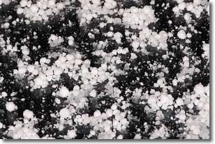
Weather Topic: What is Graupel?
Home - Education - Precipitation - Graupel
 Next Topic: Hail
Graupel is a form of precipitation that is created by atmospheric conditions
which cause supercooled water droplets to contact snow crystals and freeze to
their surface.
Sometimes known as soft hail or snow pellets, graupel is delicate and easily
destroyed by touch. Whereas hail usually falls during severe weather, graupel
doesn't require such conditions to form, and can form in mild precipitation
similar to situations which produce snowfall.
Next Topic: Hail
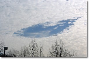
Weather Topic: What are Hole Punch Clouds?
Home - Education - Cloud Types - Hole Punch Clouds
 Next Topic: Mammatus Clouds
A hole punch cloud is an unusual occurrence when a disk-shaped
hole appears in a cirrostratus, cirrocumulus, or altocumulus cloud.
When part of the cloud forms ice crystals, water droplets in the surrounding area
of the cloud evaporate. The effect of this process produces a large elliptical
gap in the cloud. The hole punch cloud formation is rare, but it is not specific
to any geographic area.
Other names which have been used to describe this phenomena include fallstreak hole,
skypunch, and cloud hole.
Next Topic: Mammatus Clouds
Current conditions powered by WeatherAPI.com


