Weather Alert in Alaska
Flood Advisory issued June 19 at 3:58PM AKDT until June 21 at 10:00PM AKDT by NWS Juneau AK
AREAS AFFECTED: Haines Borough and Klukwan
DESCRIPTION: Warm daytime temperatures and warmer air in the lower atmosphere is raising freezing levels above 8000 feet. This will increase the amount of snow melt at higher elevations flowing into the streams and rivers. The water levels will rise and fall on a diurnal pattern. * WHAT...Flooding caused by snowmelt continues. * WHERE...The Chilkat River near areas around mile post 14 and 24 of the Haines Highway, near Klukwan and the Chilkat River Bridge. * WHEN...Until 1000 PM AKDT Saturday. * IMPACTS...Minor flooding in low-lying and poor drainage areas. * ADDITIONAL DETAILS... - At 354 PM AKDT, river gauge reports indicate rises in water levels from upper elevation snowmelt across the advisory area. Minor flooding is ongoing or expected to begin shortly, especially near the Chilkat River. - For Chilkat River at Klukwan: At 3:00pm the stage was 125.8 feet. Flood Stage is 126.0 feet. Forecast: A crest around 126.5 feet is expected around 4:00pm Saturday. Water levels will go above flood stage of 126.0 around Noon Friday. Impacts: At 126.0 feet: Bankfull stage. Water will begin to flood backyards along the Chilkat River in the village of Klukwan. At 126.5 feet: Expect flooding of yards and bank erosion near the Jilkaat Kwan Cultural Heritage Center Campus Traditional Knowledge camp in the village of Klukwan. Water will flood lower elevations in backyards along the Chilkat River near Klukwan and start to impact some smokehouse and a river access road. - For Klehini R NR Klukwan: At 3:00pm the stage was 86.4 feet.
INSTRUCTION: Stay tuned to further developments by listening to your local radio, television, or NOAA Weather Radio for further information.
Want more detail? Get the Complete 7 Day and Night Detailed Forecast!
Current U.S. National Radar--Current
The Current National Weather Radar is shown below with a UTC Time (subtract 5 hours from UTC to get Eastern Time).

National Weather Forecast--Current
The Current National Weather Forecast and National Weather Map are shown below.

National Weather Forecast for Tomorrow
Tomorrow National Weather Forecast and Tomorrow National Weather Map are show below.

North America Water Vapor (Moisture)
This map shows recent moisture content over North America. Bright and colored areas show high moisture (ie, clouds); brown indicates very little moisture present; black indicates no moisture.

Weather Topic: What is Graupel?
Home - Education - Precipitation - Graupel
 Next Topic: Hail
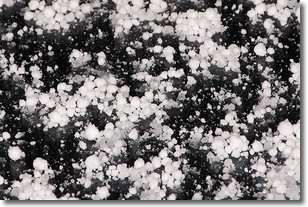
Graupel is a form of precipitation that is created by atmospheric conditions
which cause supercooled water droplets to contact snow crystals and freeze to
their surface.
Sometimes known as soft hail or snow pellets, graupel is delicate and easily
destroyed by touch. Whereas hail usually falls during severe weather, graupel
doesn't require such conditions to form, and can form in mild precipitation
similar to situations which produce snowfall.
Next Topic: Hail
Weather Topic: What are Hole Punch Clouds?
Home - Education - Cloud Types - Hole Punch Clouds
 Next Topic: Mammatus Clouds
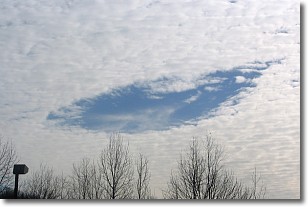
A hole punch cloud is an unusual occurrence when a disk-shaped
hole appears in a cirrostratus, cirrocumulus, or altocumulus cloud.
When part of the cloud forms ice crystals, water droplets in the surrounding area
of the cloud evaporate. The effect of this process produces a large elliptical
gap in the cloud. The hole punch cloud formation is rare, but it is not specific
to any geographic area.
Other names which have been used to describe this phenomena include fallstreak hole,
skypunch, and cloud hole.
Next Topic: Mammatus Clouds
Current conditions powered by WeatherAPI.com


