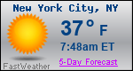
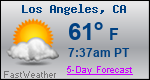
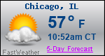
Forecast Details for Corwith, IA

Recent Locations: Corwith, IA  
This Afternoon: A 30 percent chance of showers and thunderstorms. Cloudy, with a high near 58. Windy, with a southeast wind 24 to 26 mph, with gusts as high as 37 mph. New rainfall amounts of less than a tenth of an inch, except higher amounts possible in thunderstorms.
Tonight: Showers and thunderstorms, mainly before 2am. Low around 52. Windy, with a southeast wind 17 to 22 mph becoming south southwest after midnight. Winds could gust as high as 36 mph. Chance of precipitation is 80%. New rainfall amounts between a quarter and half of an inch possible.
Saturday: Partly sunny, with a high near 71. Breezy, with a west southwest wind 9 to 17 mph, with gusts as high as 26 mph.
Saturday Night: A slight chance of showers before 10pm, then a chance of showers and thunderstorms between 10pm and 1am, then showers and possibly a thunderstorm after 1am. Low around 52. North wind 9 to 14 mph becoming east northeast after midnight. Winds could gust as high as 22 mph. Chance of precipitation is 90%. New rainfall amounts between a half and three quarters of an inch possible.
Sunday: Showers and possibly a thunderstorm. High near 69. Breezy, with an east wind 14 to 18 mph becoming south in the afternoon. Winds could gust as high as 25 mph. Chance of precipitation is 100%. New rainfall amounts between a half and three quarters of an inch possible.
Sunday Night: Showers and possibly a thunderstorm before 1am, then a chance of showers and thunderstorms between 1am and 4am, then a chance of showers after 4am. Low around 46. Chance of precipitation is 80%. New rainfall amounts between a tenth and quarter of an inch, except higher amounts possible in thunderstorms.
Monday: Partly sunny, with a high near 63. Breezy.
Monday Night: Partly cloudy, with a low around 44.
Tuesday: A 30 percent chance of showers after 1pm. Mostly sunny, with a high near 75. Breezy.
Tuesday Night: A chance of showers and thunderstorms. Mostly clear, with a low around 48. Breezy. Chance of precipitation is 50%.
Wednesday: A 40 percent chance of showers. Mostly sunny, with a high near 73.
Wednesday Night: A 30 percent chance of showers. Partly cloudy, with a low around 46.
Thursday: Mostly sunny, with a high near 67. Breezy.

Want more detail? Get the Complete 7 Day and Night Detailed Forecast!

Want to Receive our Free Daily Forecast Emails in your inbox by 5 a.m.?
There are no ads! Learn More
We respect your privacy and will not share or sell your email with anyone.

Current U.S. National Radar--Current

The Current National Weather Radar is shown below with a UTC Time (subtract 5 hours from UTC to get Eastern Time).

Current U.S. National Radar

National Weather Forecast--Current

The Current National Weather Forecast and National Weather Map are shown below.

Today's National Weather Map

National Weather Forecast for Tomorrow

Tomorrow National Weather Forecast and Tomorrow National Weather Map are show below.

Tomorrows National Weather Map

North America Water Vapor (Moisture)

This map shows recent moisture content over North America. Bright and colored areas show high moisture (ie, clouds); brown indicates very little moisture present; black indicates no moisture.

North American Water Vapor Map

Weather Topic: What are Shelf Clouds?

Home - Education - Cloud Types - Shelf Clouds

Shelf Clouds Next Topic: Sleet

A shelf cloud is similar to a wall cloud, but forms at the front of a storm cloud, instead of at the rear, where wall clouds form.

A shelf cloud is caused by a series of events set into motion by the advancing storm; first, cool air settles along the ground where precipitation has just fallen. As the cool air is brought in, the warmer air is displaced, and rises above it, because it is less dense. When the warmer air reaches the bottom of the storm cloud, it begins to cool again, and the resulting condensation is a visible shelf cloud.

Next Topic: Sleet

Weather Topic: What is Snow?

Home - Education - Precipitation - Snow

Snow Next Topic: Stratocumulus Clouds

Snow is precipitation taking the form of ice crystals. Each ice crystal, or snowflake, has unique characteristics, but all of them grow in a hexagonal structure. Snowfall can last for sustained periods of time and result in significant buildup of snow on the ground.

On the earth's surface, snow starts out light and powdery, but as it begins to melt it tends to become more granular, producing small bits of ice which have the consistency of sand. After several cycles of melting and freezing, snow can become very dense and ice-like, commonly known as snow pack.

Next Topic: Stratocumulus Clouds