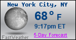
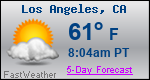
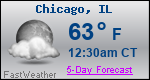
Forecast Details for New London, MN

Recent Locations: New London, MN  
Overnight: Mostly clear, with a low around 40. Southwest wind around 10 mph.
Friday: Increasing clouds, with a high near 64. West southwest wind 10 to 15 mph.
Friday Night: Showers likely, mainly after 1am. Mostly cloudy, with a low around 43. West northwest wind 5 to 10 mph. Chance of precipitation is 60%. New precipitation amounts between a quarter and half of an inch possible.
Saturday: A 20 percent chance of showers before 1pm. Mostly sunny, with a high near 59. West northwest wind 5 to 10 mph.
Saturday Night: Mostly clear, with a low around 39. Northwest wind 5 to 10 mph becoming east after midnight.
Sunday: Sunny, with a high near 67. South southeast wind 5 to 15 mph.
Sunday Night: A 20 percent chance of showers after 1am. Mostly clear, with a low around 48. Southeast wind 10 to 15 mph.
Monday: A 50 percent chance of showers, mainly after 1pm. Partly sunny, with a high near 72. Breezy, with a southeast wind 15 to 25 mph, with gusts as high as 35 mph.
Monday Night: Showers and possibly a thunderstorm before 1am, then a chance of showers and thunderstorms after 1am. Low around 53. Breezy, with a southeast wind 15 to 25 mph, with gusts as high as 40 mph. Chance of precipitation is 80%.
Tuesday: A chance of showers and thunderstorms. Mostly sunny, with a high near 68. Breezy, with a south southwest wind 15 to 20 mph, with gusts as high as 30 mph. Chance of precipitation is 40%.
Tuesday Night: A 20 percent chance of showers. Partly cloudy, with a low around 48. Southwest wind around 15 mph.
Wednesday: A 40 percent chance of showers. Partly sunny, with a high near 63. West southwest wind around 15 mph.
Wednesday Night: A 20 percent chance of showers. Mostly cloudy, with a low around 44. North wind 10 to 15 mph.
Thursday: A 30 percent chance of showers. Partly sunny, with a high near 58. North northwest wind around 15 mph.

Want more detail? Get the Complete 7 Day and Night Detailed Forecast!

Want to Receive our Free Daily Forecast Emails in your inbox by 5 a.m.?
There are no ads! Learn More
We respect your privacy and will not share or sell your email with anyone.

Current U.S. National Radar--Current

The Current National Weather Radar is shown below with a UTC Time (subtract 5 hours from UTC to get Eastern Time).

Current U.S. National Radar

National Weather Forecast--Current

The Current National Weather Forecast and National Weather Map are shown below.

Today's National Weather Map

National Weather Forecast for Tomorrow

Tomorrow National Weather Forecast and Tomorrow National Weather Map are show below.

Tomorrows National Weather Map

North America Water Vapor (Moisture)

This map shows recent moisture content over North America. Bright and colored areas show high moisture (ie, clouds); brown indicates very little moisture present; black indicates no moisture.

North American Water Vapor Map

Weather Topic: What are Cumulonimbus Clouds?

Home - Education - Cloud Types - Cumulonimbus Clouds

Cumulonimbus Clouds Next Topic: Cumulus Clouds

The final form taken by a growing cumulus cloud is the cumulonimbus cloud, which is very tall and dense. The tower of a cumulonimbus cloud can soar 23 km into the atmosphere, although most commonly they stop growing at an altitude of 6 km.

Even small cumulonimbus clouds appear very large in comparison to other cloud types. They can signal the approach of stormy weather, such as thunderstorms or blizzards.

Next Topic: Cumulus Clouds

Weather Topic: What is Drizzle?

Home - Education - Precipitation - Drizzle

Drizzle Next Topic: Evaporation

Drizzle is precipitation in the form of water droplets which are smaller than raindrops.

Drizzle is characterized by fine, gently falling droplets and typically does not impact human habitation in a negative way. The exception to this is freezing drizzle, a condition where drizzle freezes immediately upon reaching earth's surface. Freezing drizzle is still less dangerous than freezing rain, but can potentially result in hazardous road conditions.

Next Topic: Evaporation